DISCOVER DERBYSHIRE
AND THE
PEAK DISTRICT
|
DISCOVER DERBYSHIRE AND THE PEAK DISTRICT |
|
BAMFORD WALK
THE WALK
This lovely walk starts at the southern end of Derbyshire’s ‘Lake District’, at Heatherdene car park and picnic site, situated in one of the most picturesque spots in the county.
It continues through beautiful countryside with excellent views towards Win Hill and beyond, before visiting the attractive, gritstone village of Bamford. The return journey passes through pleasantly wooded countryside along a former railway track and the hamlet of Yorkshire Bridge.
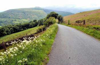
From Yorkshire Bridge Hotel, the road climbs steadily up along the flanks of the moor, with extensive views up the Hope Valley and down to Bamford. The stone used in the construction of the weir at the mill in the village came from Bamford Edge.
For a short distance, the walk takes you along the railway line, used to carry stone during the construction of the Derwent and Howden dams during the early 1900s. In the 1930s, when Ladybower was constructed, it was re-opened as a timberline. The line was purchased by the Peak District National Park Authority, and is now a bridleway and footpath.
The neat rows of houses at Yorkshire Bridge were built to provide homes for the former residents of Ashopton and Derwent. They lost their houses when the Ladybower Reservoir was constructed and the valley flooded.
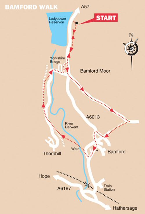
WALK DETAILS
Length: 5.25 miles.
Start/Finish: Heatherdene Car Park, or Bamford Railway Station.
Location: On the A6013, between the A57 Snake pass Road and the A6187 Hope Valley Road. Heatherdene Car Park is about half a mile north of Yorkshire Bridge. Railway Users - start at point 6.
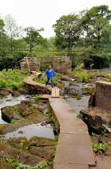
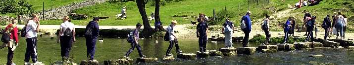
Terrain: Mainly easy walking, but with a long steady climb up New Road towards Bamford Moor. The short descent back down to Bamford is steep. The river crossing at Bamford Mill can be tricky after heavy rainfall – in favourable conditions it is one of the highlights of the walk.
THE ROUTE
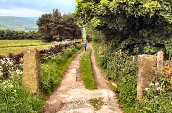
1. Leave the car park through the picnic area and follow the path to the A6013, walk up the pavement for a short distance, past the Yorkshire Bridge Hotel. 2. Turn left up New Road, which climbs up towards Bamford Edge, when the road levels out and bends to the left, go to the right at a fingerpost sign. 3. The walk descends steeply, along a partly surfaced track, before eventually arriving in Bamford. 4. At a cross roads, turn right along Taggs Knoll, passing the village primary school on your left. 5. On reaching the end of the road, turn left down the main street and follow it to the edge of the village. 6. Turn right (Railway Users coming up from the station, turn left) immediately by a speed restriction sign, just past the last house in the village, along a road with a wide entrance. 7. Walk past the former mill, now turned into flats, turn left into the car park, about two thirds of the way down the car park go to the left as directed by the sign. 8. Cross the river by an unusual combination of stepping stones and two high footbridges to reach a field on the other side. 9. Head diagonally across the field to a stile in the corner, continue in the same direction across the next field to a stile by a gate. 10. Walk down a cart track to the left of a barn to go over a stile into the next field. Turn left by a footpath sign and walk up the field, close to the hedge on your left. 11. Part way up the field, cross a stile on your left and in about 15 yards, turn right along a former railway line that has been made available to walkers. 12. The track eventually crosses a road and continues through woodland, until at a junction of paths you fork to the right, signed for Yorkshire Bridge. 13. On reaching the road turn left, and follow it round over the river bridge as it gently climbs up to the A6013. 14. Just before reaching the top of the road, turn left between the A6013 and the last row of houses (Railway users, should walk to the top of the road and turn left along the A6013 and then turn right up New Road – and continue from point 2 of the walk). 15. At the Yorkshire Bridge Hotel turn left, and retrace your steps to the starting point of the walk.
Return to the Home Page Back to the top of the Page Return to the Contents Page www.derbyshire-peakdistrict.co.uk is an independent, not for profit website. No recommendation of any establishment is implied by inclusion on this website.
|
PLACES OF SPECIAL INTEREST IN THE LOCALITY
Castleton Caverns are without doubt the most spectacular collection of caverns in the country. Speedwell (Tel 01433 620512), Blue John (Tel 01433 620638), Treak (Tel 01433 620571) and Peak (Tel 01433 620285).
The Upper Derwent Visitor Centre, (Tel. 01433 650953) located at Fairholmes, close to the Derwent Dam. Fascinating facts can be found about the area through the interactive displays. Maps, books, postcards and souvenirs can be purchased. Drinks and light refreshments available. Picnic tables. Open weekends only during the first part of the year, daily for the rest of the year.
Ladybower and the Derwent Valley is a very popular area for visitors. The dams in the valley were used by Dr Barnes Wallis and his team to test his bouncing bombs, and the film The Dambusters was partly shot here.
REFRESHMENTS
The Anglers' Rest (Tel. 01433 659415) a traditional pub, built in 1876. Located just off the main street at the top of the village, it has a small out door section. Families are welcome. Open lunchtimes and evenings during the week and all day at weekends. Meals served lunchtimes and evenings and all day on Sundays.
The Bay Tree Coffee Shop (Tel. 01433 651323) within High Peak Garden Centre, on the A6187 between Hathersage and Bamford. Hot and cold snacks. Open daily. Seating outside.
THE DISCOVER DERBYSHIRE AND THE PEAK DISTRICT GUIDE
Provides a wide range of features on towns and villages with heritage trails and detailed countryside walks, through some of the most scenically attractive countryside in the UK.
The site is expanding to include many other features of interest to the local person and visitor alike. Why not bookmark this site for future reference. 1. To return to the main site click the link below. 2. To return to the contents page of the main website click the link below.
DISCOVER DERBY A special new sub-section has been added to this website, based on the Discover Derby Supplement, published by the Derby Evening Telegraph during March 2005. The most recent additions are: Click below for details.
ON THIS SITE Every month an illustrated Newsletter is published giving details of: What's New, What's Coming and What's On.
BOOKMARK
Bookmark this site so as not to miss other town/ village features, heritage trails and countryside walks to be published shortly. Plus many more interesting features.
BAMFORD FEATURE
The superbly situated village of Bamford stands at the heart of the Dark Peak, below Bamford Edge and close to the Ladybower Reservoir and the Upper Derwent Valley Dams. It is the sole surviving village in Derbyshire’s ‘Lake District.’ The villages of Ashopton and Derwent were submerged when the Ladybower Reservoir was constructed. A well dressing festival takes place in mid-July, and another major event started in 2003, the Bamford Festival. The second festival was held in October 2004, featuring exhibitions and displays of creative work by local people, guided walks, landscape workshops, professional drama, storytelling and music. The village, though, is most famous for its sheep dog trials, which are held over the late Spring Bank Holiday.
All details on this page were correct at the time of publication, but changes may be made without notification. |