DISCOVER DERBYSHIRE
AND THE
PEAK DISTRICT
|
DISCOVER DERBYSHIRE AND THE PEAK DISTRICT |
|
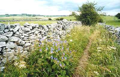
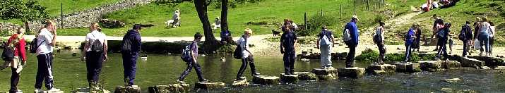
MONYASH WALK THE WALK On leaving Monyash the walk takes you through typical upland limestone countryside. In just over one mile, One Ash Grange is reached; the Cistercian monks of Roche Abbey in Yorkshire, once had a farm and manor here. Monks who had been unruly were sent as a punishment. Later it was the home of John Gratton, the Quaker preacher, and is now the site of one of the Peak District’s network of camping barns. The path drops steeply to Lathkill Dale, a National Nature Reserve, whose clear waters are reputedly the purest in the county. On the right near to the source of the river is Parson’s Tor, where the Rev Lomas fell to his death. About a quarter of a mile further on are the spoil heaps of the Ricklow Quarry where Ashford Marble was extracted.
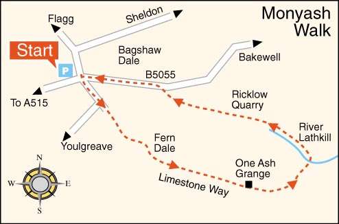
WALK DETAILS Length: 3.75 miles. Start/finish: Monyash Car Park, on the Sheldon road. Location: On the B5055 Bakewell road, about one mile from the A515 Ashbourne to Buxton road. Terrain: Apart from a steep slippery descent to Lathkill Dale an easy but very stony walk.
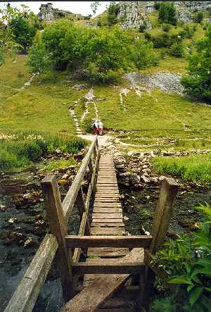
THE ROUTE 1. Walk to the right from the car park, straight on at the crossroads in the direction of Youlgreave. 2. As you walk alongside the road Fere Mere is passed on the left, when the road bends to the right the path carries straight on to join a walled track. 3. At the end of the walled track go over a stile and keeping close to the wall on the right go over another stile by a National Trust Sign. 4. Continue in the same direction angling slightly to the right to go over a stile. Then keeping close to the wall on the left cross another stile by a cattle drinking trough. 5. Near the top corner of the next field go over a stile in the wall on the left and continue with the wall on your right. 6. On reaching a farm gateway on the right, go through it to follow the track into One Ash Grange farmyard. 7. Take the sign to the left in the farmyard past a camping barn round the rear of some old cottages and with the hay shed on the left go over a stile with a steep fall. 8. Head straight on for the rocky valley beyond, where the path descends steeply before bending slightly to the left to cross the footbridge over the river. 9. Walk to the left up Lathkill Dale for about one and a half miles past Parson’s Tor on the right and through Ricklow Quarry. 10. Turn left at the Monyash to Bakewell road and head back towards the village going up the main street and turning right at the crossroads back to the start of the walk.
Return to the Contents Page Back to the top of the Page Return to the Home Page www.derbyshire-peakdistrict.co.uk is an independent, not for profit website. No recommendation of any establishment is implied by inclusion on this website.
|
PLACES OF INTEREST IN THE LOCALITY Magpie Lead Mine (tel 01629 583834) leased to the Peak District Mines Society, the surface remains are the best example in Britain of a 19th century lead mine with impressive mine buildings and winding gear. Ring for opening details. For more information see special feature Arbor Low Stone Circle, a huge stone circle consisting of a ring of stones surrounded by a grass bank and a ditch. No one knows for certain, if the stones originally stood upright. Over Haddon, a picturesque village overlooking Lathkill Dale, with Haddon Hall only about one mile away. In 1854, it became Derbyshire's 'Klondike' when it was thought gold had been discovered in a lead mine. A company was formed and plans were made to build a railway line. Alas, it was nothing more than iron pyrites. REFRESHMENTS The Bull’s Head (Tel. 01629 812372) a fine old village pub with beamed ceilings and an imposing coat of arms above the stone fireplace. Home-cooked snacks and meals served lunchtime and evenings. Eat in the main bar or in a separate dining room. A beer garden and outside seating are available. The Old Smithy (Tel. 01629 814510) formerly a Blacksmith’s shop which has been converted into a very popular café. Musical instruments adorn the walls. Bistro evenings take place most Saturdays – telephone for details. The café is now licensed. There is seating outside by the green. Open daily weekdays from 10am, weekends from 9am. DERBYSHIRE AND THE PEAK DISTRICT GUIDE
Provides a wide range of features with heritage trails and detailed countryside walks, through some of the most scenically attractive countryside in the UK.
1. To return to the main site click the link below. 2. To return to the contents page of the main website click the link below.
DISCOVER DERBY A special new sub-section has been added to this website, based on the Discover Derby Supplement, published by the Derby Evening Telegraph during March 2005. The most recent additions are: Click below for details. MONYASH FEATURE Situated in limestone country at the head of beautiful Lathkill Dale is the sturdy little village of Monyash with its neat rows of houses, attractive green and pond.
The wide grass verges near the Chandler's House were used as a ropewalk, and much later to stack incendiary bombs during the Second World War before transportation to an ammunition site.
All details on this page were correct at the time of publication, but changes may be made without notification. |