DISCOVER DERBYSHIRE
AND THE
PEAK DISTRICT
|
DISCOVER DERBYSHIRE AND THE PEAK DISTRICT |
|
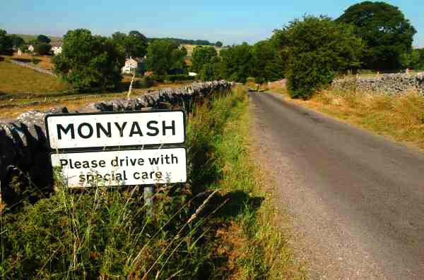
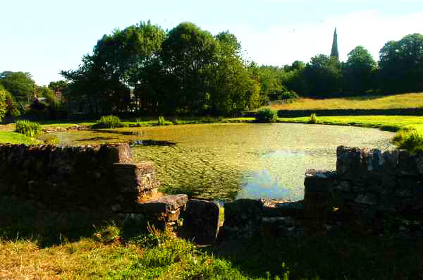
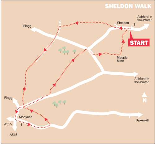
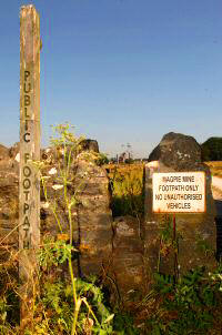
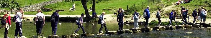
SHELDON WALK THE WALK This is a refreshing upland walk, with wild flowers in spring and summer adding to the enjoyment. The eye-catching limestone village of Monyash is visited on the outward journey. On the return trip, Magpie Mine stands one third of a mile south of the village of Sheldon, from where it can be seen standing darkly silhouetted against the skyline. Monyash is situated at the head of beautiful Lathkill Dale; it is a sturdy little village with its neat rows of houses, attractive green and pond. It is formerly an important lead mining centre for the High Peak. But the importance of Monyash goes back much further. People from pre-historic times have been attracted to the area as evidenced by the stone circle at nearby Arbor Low, the ancient trackways and burial mounds. Bagshaw Dale is a dry dale, but can become very muddy where animals have stood in wet weather, when it might be preferred to walk back through the village to the Sheldon Road (Point 11). Magpie Mine is about 1050 feet above sea level. Footpaths approach it both from Sheldon and the Monyash to Ashford-in-the-Water road. Members of the public may visit it for external inspection at any reasonable time.
WALK DETAILS Length: 6 miles. Start/Finish: Main Street, Sheldon. Location: Off B5055 Bakewell to Monyash road. Terrain: Relatively flat upland walking, through stone-wall country. It can be quite breezy.
THE ROUTE 1. Walk up the street, past Top Farm and follow the road round to the left. About 75yards after leaving the last building behind, go over a stile on the right, by a fingerpost sign into a field. 2. Aim towards the far left hand corner of the field to a squeezer stile, and then cross the corner of the next field. 3. Enter another field; turn right, angling slightly to the left of a wall that juts out into the field, to reach a stile 20 yards from the right hand corner of the field. 4. Continue to maintain the same direction for the next four fields. 5. Cut across the corner of the fifth field, and in the next field head to the right to a stile 35 yards from the left hand corner. 6. In the next field go over a stile to the right of an electricity pole and angling very slightly to the left down another field, go over a stile at the bottom and turn left up a wide track. 7. Cross a minor road and walk down a walled path on the opposite side, stay on this until it ends and you enter a field. Continue straight on, keeping to the right side of a series of fields. 8. After passing a small wood on your right and going over a stile, turn left and cross the corner of a field to another stile. Once over the stile, keep close to the wall on your left all the way to Monyash. 9. On reaching the Sheldon Road, go to the right and then left at the ‘T’ Junction into the centre of Monyash. Turn left again in the village onto the B5055 for Bakewell. 10. After leaving the village behind watch out for a path on your left, a few yards before the path to Lathkill Dale, which is on the opposite side of the road. 11. Walk up a clear path along the bottom of the dale, which soon leads you back to the Sheldon road, where you turn right. 12. About 100 yards after passing the drive to Nursery Fields Farm, go through a stile on the left into a field. Walk to the far right hand corner of the field, pass through a gateway. 13. Turn right by the wall, and cross a stile 15 yards from the right hand corner of the field. Continue in the same direction across two narrow fields. 14. Aim slightly to the left in the next field to the far corner. 15. For the next two fields follow the wall on your left. (Note: The stile dividing the fields takes you onto the opposite side of the wall, but within 10 yards you go back through a stile, by a gate, to the side you want to be on.) 16. After entering another field, angle slightly away from the wall to a stile 40 yards from the corner of the field. Cross the corner of the next field to go through a narrow wood, and then walk straight ahead along the side of a boundary fence to a minor road. 17. Turn right, ignore the road to Sheldon, and after a further 100 yards, at the bottom of a hollow, turn left at a stile beside a gate. 18. Follow a rough path to the left of a dew pond, to pass through a gap in the corner of the field. Go through another gap a few yards away heading towards the mine buildings you can see in front. 19. At first the path heads slightly to the left of the buildings, but it changes course a little as you get closer - most of the mine workings are on your left by the time you arrive. 20. Pass through the buildings and turn left along the track in front of the mine, which you follow round to reach a wall, which you do not cross. 21. Turn right, keeping close to the wall on your left, and walk to a stile in the far corner of the field. 22. Cross two fields along a clear path, heading towards some farm buildings you can see in the distance, and then turn right down a walled farm track. 23. Continue on the right when a small field is entered, to go through the gate at the rear of some farm buildings. Turn left and aim for a stile just behind the farm buildings. 24. Cross an enclosure to a stile by a yellow footpath marker, go over a stile along the bottom of a field and join a narrow path leading to Sheldon Village Street and the start of the walk.
Return to the Home Page Back to the top of the Page Return to the Contents Page www.derbyshire-peakdistrict.co.uk is an independent, not for profit website. No recommendation of any establishment is implied by inclusion on this website.
|
PLACES OF SPECIAL INTEREST IN THE AREA Magpie Lead Mine (Tel 01629 583834) leased to the Peak District Mines Society, the surface remains are the best example in Britain of a 19th century lead mine with impressive mine buildings and winding gear. The site can be explored on foot at any reasonable time. Ring for special opening details. Bakewell Old House Museum (Tel 01629 813642) the oldest house in Bakewell, dating from the 1530s, acts as an atmospheric backdrop for a superb collection of costumes, textiles, toys, agricultural and industrial history. Open from 1 April to 31 October, from 11-4pm. Haddon Hall (Tel 01629 812855) perhaps the most perfect example of a medieval manor house in the country. The gardens are a delight and believed to be the most romantic in Britain, being the setting for the elopement of Dorothy Vernon and John Manners. Please telephone for details or visit website. REFRESHMENT STOPS Cock and Pullet (Tel. 01629 814292) this attractive village pub, opened in 1995, was once a farm building. The coal fire, beams and lovely antique furniture make this excellent little pub seem to be one of the oldest in The Peak National Park rather than one of the youngest. Open daily. Food served lunchtimes and evenings. Accommodation available.
The Old Smithy (Tel. 01629 814510) formerly a Blacksmith’s shop which has been converted into a very popular café. Musical instruments adorn the walls. Bistro evenings take place most Saturdays – telephone for details. The café is now licensed. There is seating outside by the green. Open daily weekdays from 10am, weekends from 9am.
THE DISCOVER DERBYSHIRE AND THE PEAK DISTRICT GUIDE
Provides a wide range of features with heritage trails and detailed countryside walks, through some of the most scenically attractive countryside in the UK.
1. To return to the main site click the link below. 2. To return to the contents page of the main website click the link below.
DISCOVER DERBY A special new sub-section has been added to this website, based on the Discover Derby Supplement, published by the Derby Evening Telegraph during March 2005. The most recent additions are: Click below for details.
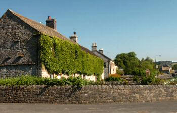
SHELDON FEATURE Sheldon is a lovely upland village perched high above the River Wye. It is situated three miles west of Bakewell off the A6, with the villages of Ashford-in-the-Water and Monyash only a short distance away. It has one street with a mixture of old houses and farms on both sides. Mature trees and attractive grass verges add to the charm of this Conservation Village. The views just outside the village of the Wye Valley and the lower part of Monsal Dale are excellent. A good place to enjoy the panoramic views is close by the children’s play area, where visitors are frequently seen eating their food at the picnic tables provided.
All details on this page were correct at the time of publication, but changes may be made without notification.
|