DISCOVER DERBYSHIRE
AND THE
PEAK DISTRICT
|
DISCOVER DERBYSHIRE AND THE PEAK DISTRICT |
|
WINSTER WALK THE WALK Ancient Britons and lead miners were once very much in evidence on this fascinating walk, and at one time you could even meet a hermit anxious to guide you on your way and keep you safe from harm.
The Portway, a very ancient highway that may date back before Roman times, is followed for the first part of the walk. By the side of the track, the remains of miners’ huts – many miners used to supplement their income by keeping cows – are much in evidence.
The Hermit’s Cave at Cratcliffe Rocks was at one time home to a hermit. In the middle ages hermits were looked on as holy men. Appointed to lonely places by a bishop, they rendered hospitality and assistance to travellers.
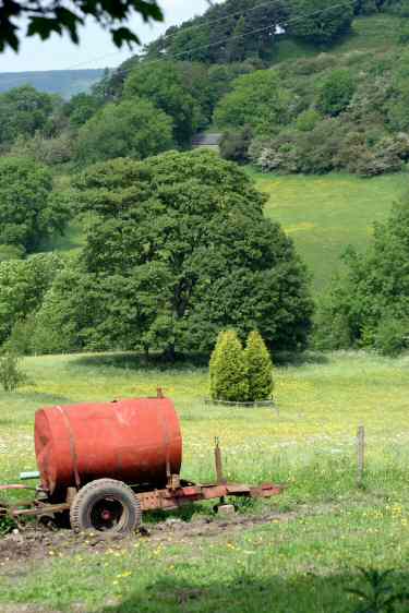
Birchover is skirted round and when Uppertown Farm is reached, look out for the old village stocks sited in front of the farm. The route drops quite steeply from Uppertown into a valley that can be very wet at times. Fortunately, lead miners laid paving stones to assist them on their journey to Mill Close Mine, near Stanton-in-Peak, where most of them worked when the mining boom in Winster ended.
WALK DETAILS
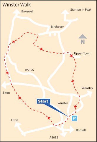
Length: 5 miles.
Start/finish: Winster Car Park, just off B5056 at the southern entry to the village.
Location: On the B5056 between A5012 (Cromford to Newhaven) and A6 (Matlock to Bakewell).
Terrain: Some short steep gradients, but nothing too strenuous. Can be very muddy in places.
THE ROUTE
1. From the car park, walk back across the B5056 and continue along the road towards Elton/Newhaven for a short distance, before turning right down a rough track opposite a road coming in from the left.
2. Follow the track down, crossing a farm access road, go straight over a road and walk to the bottom of Dudwood Lane, where Cratcliffe Rocks can be seen ahead. Here you join the B5056.
3. Walk carefully to the left along the narrow verge to the B5056 for 100yards, before turning right at a footpath sign for Birchover.
4. Ascend a steep field, through a group of thorn bushes, to a stile at the top.
5. Continue straight on along a farm track to the outskirts of Birchover, before turning right in front of some gates, with just beyond an attractive ornamental pond set in a large garden.
6. Follow the path up a short slope and go to left along a road leading towards a house. Just before reaching the house, where the road bends to the right, go through the stile directly in front of you and turn sharp left.
7. Keeping close to the hedge on the left cross two fields and continue along a narrow path.
8. Maintain the same direction over thee more fields, this time with the hedge on the right, before going down a track past Uppertown Farm to the road.
9. Turn left along the road, within 20 yards go to the right to follow an access road. Take the stile on the right just before Ivy House Farm and walk straight down a small field to a stile.
10. Continue for a short distance down a fenced path turning right at the end and then left at a fingerpost sign to descend a short steep section heading towards a stile at the bottom of the field.
11. Go straight down the next field, through a stile and over a flagged path to another stile.
12. Continue along an obvious path to join another flagged path as it winds uphill, eventually reaching a track and then a village road into Winster.
13. Turn left at the main street and almost immediately right, in front of the Market House and walk up the street going to the right where the road forks.
14. Follow the road round until about half way across the flat section, opposite Orchard Cottage, turn left and follow the path up a long flight of steps past the Methodist Chapel.
15. At the top, turn right along the road that leads you back to the starting point of the walk.
Return to the Home Page Back to the top of the Page Return to the Contents Page www.derbyshire-peakdistrict.co.uk is an independent, not for profit website. No recommendation of any establishment is implied by inclusion on this website. |
PLACES OF SPECIAL INTEREST IN THE AREA The Old Market Hall at Winster dates back to the 17th century when the village was granted the right to hold a market. It became the first National Trust property in Derbyshire and the Peak District in 1906 and it is now used as an exhibition and information centre. For further information website: www.nationaltrust.org.uk Middleton Top (tel 01629 823204) the Visitor Centre tells the story of the Cromford and High Peak Railway. The track has been resurfaced for the benefit of walkers and cyclists and is known as The High Peak Trail. Shop facilities and cycle hire available. The Engine House opens on a limited basis. Ring for details. Nine Ladies Stone Circle, on Stanton Moor where according to legend nine ladies danced here on the Sabbath Day and were turned to stone as a punishment, along with the fiddler who stands nearby. REFRESHMENTS The Miners Standard (Tel 01629 650279) 17th century oak beamed pub full of interest and character. The name is derived from the dish that local lead miners used for measuring ore – the miners standard! A small sign inside proclaims ‘pub of the year 1653’, the year that it was built. There is beer garden and children’s play area. The restaurant is being refurbished. Bar snacks are available daily at lunchtime throughout the year, also in the evenings every day in summer, but check for availability in winter. Elton Tea Rooms (Tel 01629 650217) are a popular haunt for cyclists and ramblers. Full of character with old advertising signs adorning the walls, a grandfather clock in the corner and a National Cash Register to record sales. A wide range of healthy homemade meals and snacks are available. Open Sundays only, please check for details before travelling. THE DISCOVER DERBYSHIRE AND THE PEAK DISTRICT GUIDE
Provides a wide range of features with heritage trails and detailed countryside walks, through some of the most scenically attractive countryside in the UK.
1. To return to the main site click the link below. 2. To return to the contents page of the main website click the link below.
DISCOVER DERBY A special new sub-section has been added to this website, based on the Discover Derby Supplement, published by the Derby Evening Telegraph during March 2005. The most recent additions are: Click below for details.
ON THIS SITE Every month an illustrated Newsletter is published giving details of: What's New, What's Coming and What's On.
WINSTER FEATURE
It is a village that retains its 18th century character, with over 60 listed buildings in its Conservation Area. The brightly painted houses, often with fascinating names, are set on the gently rising hillside alongside winding lanes and pathways.
Little seems to have changed since the houses were built and in keeping with the village’s traditional appearance many of its old customs have been retained. Winster is an ancient settlement mentioned in the Domesday Survey. But it was only when lead mining commenced in earnest, that it came to prominence. At the height of the mining boom in the mid 18th century, it was considered to be the fourth largest town in the county.
All details on this page were correct at the time of publication, but changes may be made without notification. |